News | Flooding in Paradise: PSR Researchers Propose Green Solutions for Rising Sea Levels in Oahu
Stop the VideoNews
Flooding in Paradise: PSR Researchers Propose Green Solutions for Rising Sea Levels in Oahu
Monday, June 7, 2021
In a culture formed around their coastal and marine environments, communities in Hawaii are suffering from growing concerns relating to coastal hazards like accelerating erosion, sea level rise, and coastal storms that threaten to flood roadways and new rail infrastructures on the islands. While “hard” structures like seawalls, bulkheads, and rock revetments have been consistently used to protect the coasts from wave energy, they cause detrimental erosion and have already led to the loss of more than 5 miles of beaches on Oahu. Wave run-up and erosion will worsen as the sea level rises, and the State’s Climate Change Commission encourages identifying measures and policies to adapt coastal development to future sea level rise. In “A Primer on Coastal Transportation System Resilience and Adaption to Sea Level Rise on Oahu Using Living Shorelines and Green Infrastructure,” Professor Wendy Meguro and Junior Research Associate Rebecca Ogi from the University of Hawaii present green alternatives to hard shoreline structures to Hawaii’s government planners and policymakers, private landowners, developers, and design teams.
This research serves as a methodological primer—an initiative to inform and aid the government’s decision to further investigate green alternatives (e.g., living shorelines and nature-based infrastructure) to hardened shorelines. Living shorelines integrate habitat restoration, coastal engineering, and conservation to reduce erosion, wave damage, and flood risks (NOAA 2015), and they could potentially provide protection for coastal transportation systems. The research summarizes existing studies from the scientific, government and policy communities, and illustrates how different living shorelines and green infrastructure measures could be used in the three prototypical coastal locations on Oahu—Sunset Beach, Waikiki Beach, and Waipahu Transit Oriented Development Area—with different economic conditions, physical development conditions, and wave intensities. The research provides well-developed case studies illustrating a range of potential living shorelines alternatives, their viability under different conditions, and discusses recent international examples. In particular, the scale models and drawings visualize design and planning considerations for potential new, prototypical living shorelines and coastal roadways. These visual aids allow stakeholders to discuss the economic, social, and environmental benefits as well as the design, planning, and policy implications.
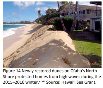
Located on the North Shore of Oahu as a recreationally significant rural coastal community location, Sunset Beach features a sandy beach with a fringing reef and has prototypical high wave energy with steeply sloped topography. Identified as highly vulnerable to coastal hazards, Sunset Beach often experiences large winter waves that regularly cause erosion and threaten roads and homes. The coastal roads, bicycle path, and houses are built atop former dunes, problematically preventing the beach’s long-term landward migration. Recognizing the potential for long-term redevelopment due to the low building development density in Sunset, Meguro and undergraduate student Cristina Holcom propose potential living shorelines strategies: Retreat, Rise, and Revitalize. “Retreat” proposes the relocation of homes, roads, and low-rise development landward to lessen exposure to damages from sea level rise. “Rise” signifies the importance of wet floodproofing any structures remaining in the sea rise level exposure area and adding boardwalks to prevent compaction of dunes. Lastly, “Revitalize” involves restoring the beach dunes and planting native vegetation to stabilize the dunes, slow erosion, and buffer wave energy. Revitalization of a coastal bike path and open green space would create a place for recreation, restore habitat, and reduce damage from high wave events.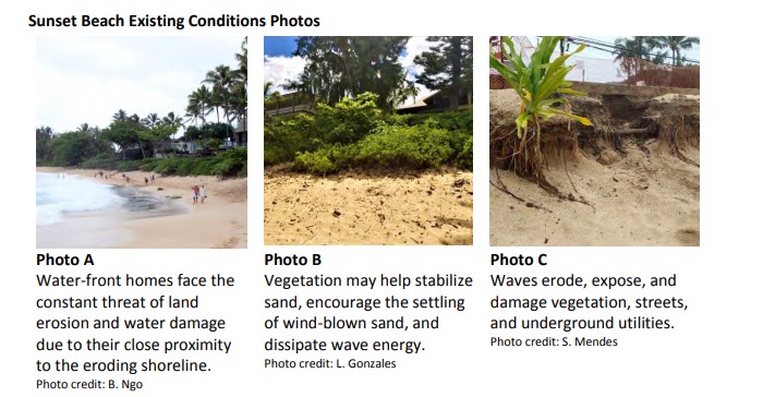
A densely-developed coastal community and economic engine on the South Shore of Oahu, Waikiki Beach represents a prototypical man-made sandy beach with medium-wave energy with a flatter sloped topography and shallower underwater terrain relative to the other sites. Highlighting Waikiki’s high economic value and dense urban development, Honolulu’s former Mayor Kirk Caldwell previously noted the difficulty of relocations. However, due to the shoreline’s proximity and Waikiki beach’s flat topography, selected buildings are impacted by waves and other buildings and roadways have a high likelihood of experiencing future flooding. High inland flooding risks suggest the need for efforts to evaluate options for long-term sea level rise adaptation. The direct marine flooding is currently mitigated by beach nourishment (i.e., periodic replacement of the sand), a site-appropriate living shoreline strategy anticipated to continue in the future. The strategy proposal focuses on the vegetation restoration between the shoreline and built environment and coral reefs as natural breakwaters to reduce and dissipate wave energy. Moreover, the construction of offshore breakwaters further out in the ocean can shelter potential coral reef restoration, but would require evaluation of surfing impacts. Additional infrastructure such as an elevated boardwalk will encourage vegetation to thrive at the ground level while providing dry pedestrian paths during floods or tidal events. This strategy also emphasizes providing coveted space for beachgoers and educating visitors and residents about their responsibility in flood mitigation.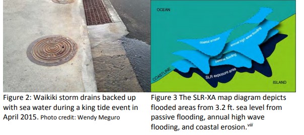
Known as a low-wave energy environment, the Waipahu Transit-Oriented Development (TOD) area is an existing suburb with plans for denser development around the new rail station in the future. In contrast to the other study sites, the researchers focused on flood protection strategies to safeguard Waipahu TOD’s roadways and buildings from elevated water levels caused by sea level rise and rainfall rather than wave energy. The researchers highlighted the following green infrastructure planning strategies to combat flooding: water infiltration and detention in bioswales, (a stormwater control feature that uses a combination of an engineered basin, soils, and vegetation to slow and detain stormwater); and redeveloping open spaces around the rail station into parks and plazas designed to detain stormwater during rainy periods and used for recreation and habitat creation during dry periods. Building upon Guzman et al.’s 2018 study titled “Design Guidelines for Urban Stormwater Wetlands,” the research team found that the Waipahu area would benefit from developing recreational stormwater detention areas that simultaneously provide green community spaces and capture and purify stormwater. To prevent overtopping of stream banks, an increase in the width of the floodways along the waterways was also recommended. Such modifications have been used in places like Wailani and have led to benefits for ecological restoration and protection, as well as transportation and recreation. Gray infrastructure strategies complement the green infrastructure with proposed permeable pavement that allows stormwater infiltration and high-volume water detention strategies that will temporarily store runoff from large rain events to prevent roadway flooding.
Current and future coastal hazards plaguing Hawaii have been further exacerbated by the hard shoreline-armoring protections that erode the natural protections found along the coast. Meguro and Ogi’s proposed living shorelines provide green alternatives that not only mitigate erosion and flooding in coastal roadways and communities, but also create ecological and recreational assets. The State’s call for sea level rise adaptation planning and research exemplifies residents’ dedication to preserving the islands’ longstanding commitment to sustainability and safety.
News Archive
- December (1)
- November (6)
- October (4)
- September (2)
- August (3)
- July (4)
- June (3)
- May (7)
- April (8)
- March (11)
- February (8)
- January (7)
- December (7)
- November (8)
- October (11)
- September (11)
- August (4)
- July (10)
- June (9)
- May (2)
- April (12)
- March (8)
- February (7)
- January (11)
- December (11)
- November (5)
- October (16)
- September (7)
- August (5)
- July (13)
- June (5)
- May (5)
- April (7)
- March (5)
- February (3)
- January (4)
- December (4)
- November (5)
- October (5)
- September (4)
- August (4)
- July (6)
- June (8)
- May (4)
- April (6)
- March (6)
- February (7)
- January (7)
- December (8)
- November (8)
- October (8)
- September (15)
- August (5)
- July (6)
- June (7)
- May (5)
- April (8)
- March (7)
- February (10)
- January (12)
2024
2023
2022
2021
2020
2019
2018
2017
2016
2015
2014
2013
2012
2011
2010
Major Funders


Metrans Associate Partners