News | USC Graduate Kavina Patel Combines STEM and Humanities for a Full Picture of the NYC Subway
Stop the VideoNews
USC Graduate Kavina Patel Combines STEM and Humanities for a Full Picture of the NYC Subway
Friday, October 30, 2020
When USC Urban Planning Master’s student Kavina Patel saw the stunning photos of New York transit station areas taken by Professor Emeritus Martin Krieger of the USC Sol Price School of Public Policy, she was inspired to find a way to connect them with her passion for the inter-relationships between transportation, community, and city development. After twenty years of systematically photographing Los Angeles, Krieger’s curiosity was piqued by the discussions of transit-oriented development in urban planning and real estate development. With an interest in capturing the identities of the individual stations and the unique impact experienced by each, he began photographing the century-old New York City subway system and accumulated an abundance of photographs from the ends of all the lines. By using these photographs to show a visual interactive story, Patel could show the amalgamation of community subcultures and the relationship between these distinctive communities and transportation system accessibility.
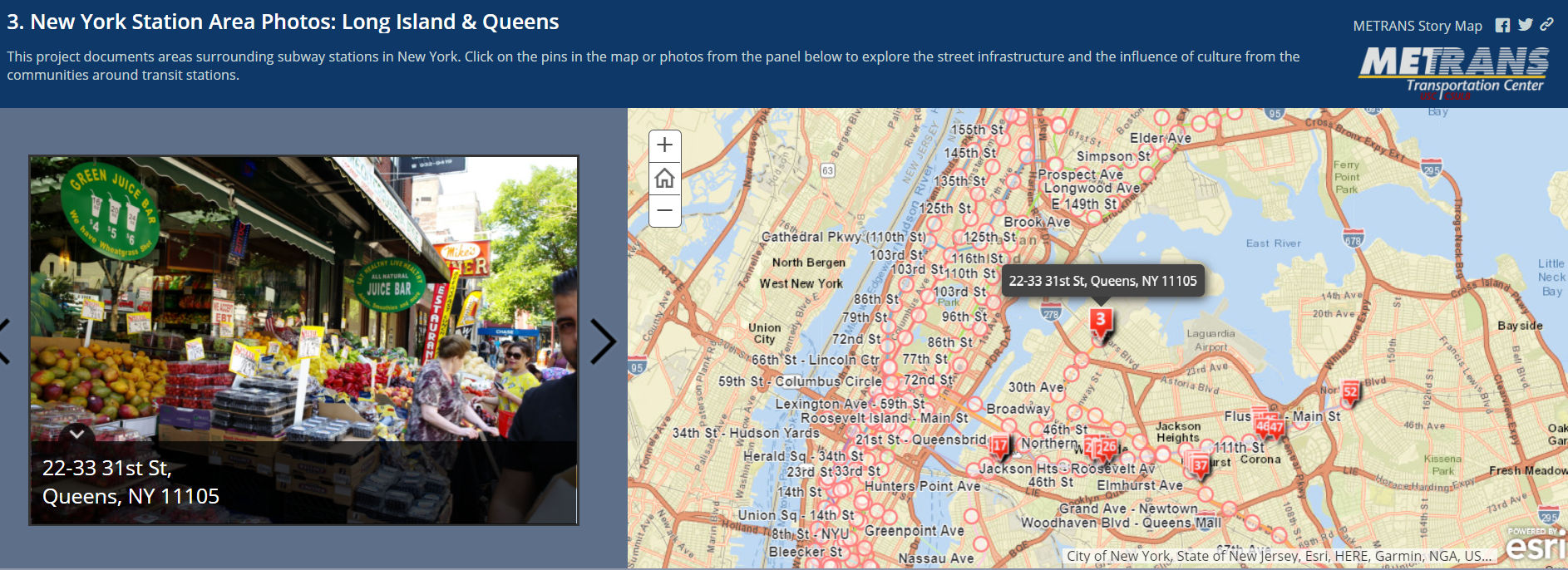
Patel’s five-part story map project mapped a total of approximately 500 of Krieger’s photos from select areas around subway stations in New York and New Jersey, highlighting the surrounding cultures and their interaction and integration with their public transit systems. Combining photography and city planning allows for an exploration of the street infrastructure and the influence of diverse cultures around the transit stations on that infrastructure. Patel feels this is vital for a thoughtful and successful discussion of what she refers to as “transitory inter-development,” the interdependency between transportation, community, and city development. The transit stations each tell a visual story because of their diverse surroundings, bringing to life Krieger’s idea that “an identity is a matter of manifold presentations of profiles or aspects.” Some transit locations are surrounded by family-owned shoe repair businesses and barbershops, while others are located right next to Indian restaurants and shops. Patel highlighted the power of images to convey that “Each station has such a unique identity and that is something that this project tries to convey.”
The most challenging but similarly rewarding part of the project was experimenting with the best way to display the data for ease of access, a process that involved exploring five different methods of data presentation and took over two months of trials and testing. Patel ultimately decided on story maps. These maps are interactive, with each photo geographically tagged so that the researcher is able to click on any of the location pins placed on the map and be transported instantly to street level to explore the street infrastructure and the culture of the surrounding area. The medium allows for an immersive experience that can virtually transport viewers to the eclectic subcultures that define the New York experience.
There are five story maps organized around different groups of stations:
Story Map 1: Brooklyn Stations
Story Map 2: Brooklyn & Staten Island Stations
Story Map 3: Queens
Story Map 4: Queens/ Bronx
Story Map 5: Manhattan/ Jersey City
This project was a culmination of a year of work for Patel and her project team of many dedicated students and professors including Project Directors Gen Giuliano, METRANS Director, and Victoria Valentine-Deguzman, METRANS Associate Director of Education and Professional Development.
News Archive
- December (1)
- November (6)
- October (4)
- September (2)
- August (3)
- July (4)
- June (3)
- May (7)
- April (8)
- March (11)
- February (8)
- January (7)
- December (7)
- November (8)
- October (11)
- September (11)
- August (4)
- July (10)
- June (9)
- May (2)
- April (12)
- March (8)
- February (7)
- January (11)
- December (11)
- November (5)
- October (16)
- September (7)
- August (5)
- July (13)
- June (5)
- May (5)
- April (7)
- March (5)
- February (3)
- January (4)
- December (4)
- November (5)
- October (5)
- September (4)
- August (4)
- July (6)
- June (8)
- May (4)
- April (6)
- March (6)
- February (7)
- January (7)
- December (8)
- November (8)
- October (8)
- September (15)
- August (5)
- July (6)
- June (7)
- May (5)
- April (8)
- March (7)
- February (10)
- January (12)
2024
2023
2022
2021
2020
2019
2018
2017
2016
2015
2014
2013
2012
2011
2010
Major Funders


Metrans Associate Partners