News | PSR Researchers Promote Connected Emission Control Technologies for Freight Vehicles
Stop the VideoNews
PSR Researchers Promote Connected Emission Control Technologies for Freight Vehicles
Friday, July 2, 2021
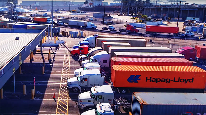
Heavy duty trucks (HDTs) are a well-known essential element of the commerce within and between California communities. Despite their importance, HDTs are also a major contributor to air pollutant emissions that negatively affect the health of communities they traverse. The 30% of California citizens who live within 100 yards of major roadways are particularly vulnerable, as they are exposed to 2-4 times more harmful pollutants. Luckily, connected vehicle (CV) technology, which allows communication and information to be shared between vehicles and infrastructure, might offer solutions. Toward that end, a team of researchers has undertaken a study that seeks to use CV technology to develop new routing algorithms for heavy-duty trucks, reducing human exposure to pollution without hindering the work freight vehicles do.
The study, “Connected Emission Control Technologies for Freight Vehicles” is led by Research Engineer Dr. Kanok Boriboonsomsin from the University of California, Riverside (UCR), along with UCR Assistant Project Scientist Dr. Ji Luo, former Ph.D. student Chao Wang, and Director of the Center for Environmental Research and Technology Matthew Barth with funding from the Pacific Southwest Region University Transportation Center (PSR).
CV technology has emerged as a major innovation, with potential applications that could reduce traffic accidents, road congestion, and the emission output of vehicles. One example of CV applications is eco-routing, which could reduce emissions as well as community exposure to emissions through finding travel routes between origins and destinations that result in the least amount of vehicle emissions. Furthermore, new applications of CV technology can be created and implemented, with positive benefits for the environment and public health. In this study, the researchers create new routing algorithms that direct freight traffic away from people in communities.
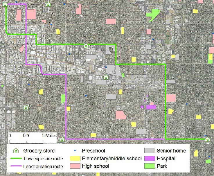
A case study was conducted in the Reseda-Northridge area of the San Fernando Valley in Southern California to determine the effectiveness of the methodology in a densely populated community with high proportion of children and seniors who are generally more sensitive to air pollution. The research began with an understanding of the level of air pollution humans are exposed to when a truck travels on a particular road. After a baseline was established, the algorithm was then implemented to identify the best possible route to minimize residents’ exposure to air pollution from the truck. The study estimated the amount of pollution the truck emits, how far and in which direction the pollutant is dispersed, and how many people live, work, and play within that vicinity. Four hundred trips were simulated to evaluate the validity and effectiveness of the methodology.
The methodology included five sequential steps: traffic activity acquisition, vehicle emission modeling, dispersion modeling, exposure assessment, and vehicle routing. Traffic activity acquisition is meant to capture the overall traffic flow, traffic speed, and fleet composition. The traffic speed on the roads was determined by the posted speed limit. Vehicle emissions modeling utilizes a model (I.e. EMFAC2011) developed by the California Air Resources Board (CARB) to determine the amount of emissions per mile produced by the vehicle. Based on the traffic speed, link-by-link emissions factors were then saved as new attributes of the roadway network. Dispersion modeling estimates the concentration of air pollutants from the vehicle at specified receptor locations. Exposure assessment captures the amount of air pollutant inhaled by a set group of subjects. The vehicle routing is aimed at finding a route with low exposure at an affordable cost. In order to ensure that the routes were the most efficient, 400 different trips were taken from one side to the other. Combining the fastest route with the lowest exposure route helped determine the most effective route. Statistically, the travel time would potentially increase by 3 percent or 40 seconds and in return the ROG inhaled, and total mass of PM 2.5 would decrease by 76 and 87 percent.
The researchers found that low exposure routes created by the new routing algorithms are impacted by several different factors, like vehicle characteristics, atmospheric conditions, and population activities. They also found that changing routes to avoid the target populations reduced pollutant exposure by more than 30% in 40% of the simulated trips compared to the fastest available route, leading to only a small increase in trip duration. The researchers believe that the low exposure route created by the CV routing algorithms can be used with clean vehicle technology to reduce human exposure to harmful pollutants even more. The first effort made to apply CV technology as a way to reduce human exposure to traffic-related air pollution, the researchers believe that the concept will potentially benefit disadvantaged communities that are impacted by air pollution as well as sensitive facilities like schools and hospitals.
As freight demand is expected to double by 2040, the need for long-term solutions for the industry's pollution problems becomes even more pronounced. Such solutions as CV technology would help mitigate the impact of emissions from trucks, cutting down on human exposure to this pollution while allowing the industry to meet the demand for the movement of goods. With a reduced environmental and health impact from heavy-duty trucks, communities will be able to breathe a little easier.
Figure 10. LER and LDR of an example trip
News Archive
- December (1)
- November (6)
- October (4)
- September (1)
- August (3)
- July (4)
- June (3)
- May (7)
- April (8)
- March (10)
- February (8)
- January (7)
- December (7)
- November (8)
- October (11)
- September (11)
- August (4)
- July (10)
- June (9)
- May (2)
- April (12)
- March (8)
- February (7)
- January (11)
- December (11)
- November (5)
- October (16)
- September (7)
- August (5)
- July (13)
- June (5)
- May (5)
- April (7)
- March (5)
- February (3)
- January (4)
- December (4)
- November (5)
- October (5)
- September (4)
- August (4)
- July (6)
- June (8)
- May (4)
- April (6)
- March (6)
- February (7)
- January (7)
- December (8)
- November (8)
- October (8)
- September (15)
- August (5)
- July (6)
- June (7)
- May (5)
- April (8)
- March (7)
- February (10)
- January (12)
2025
2024
2023
2022
2021
2020
2019
2018
2017
2016
2015
2014
2013
2012
2011
2010
Major Funders


Metrans Associate Partners