News | Two CITT Research Assistants Named Finalists in SCAG Story Map Competition
Stop the VideoNews

PSR METRANS UTC
Two CITT Research Assistants Named Finalists in SCAG Story Map Competition
Thursday, September 6, 2018
 The Center for International Trade and Transportation (CITT), housed at Long Beach State University, sent two of the Center’s research assistants, Sean Reseigh and Benjamin Olson, to SCAG’s 53rd Regional Conference and General Assembly as finalists for an Esri Story Map Competition.
“It was such a valuable experience to be able to attend the SCAG General Assembly and witness the sharing of ideas between regional transportation leaders and network with local companies,” said Olson.
“The SCAG General Assembly was a highly valuable experience that exposed me to the State's leaders in transportation planning and development and infrastructure development. Sharing our Story Map with SCAG employees and other college students was a significant career stepping stone for both Ben and I,” said Reseigh.
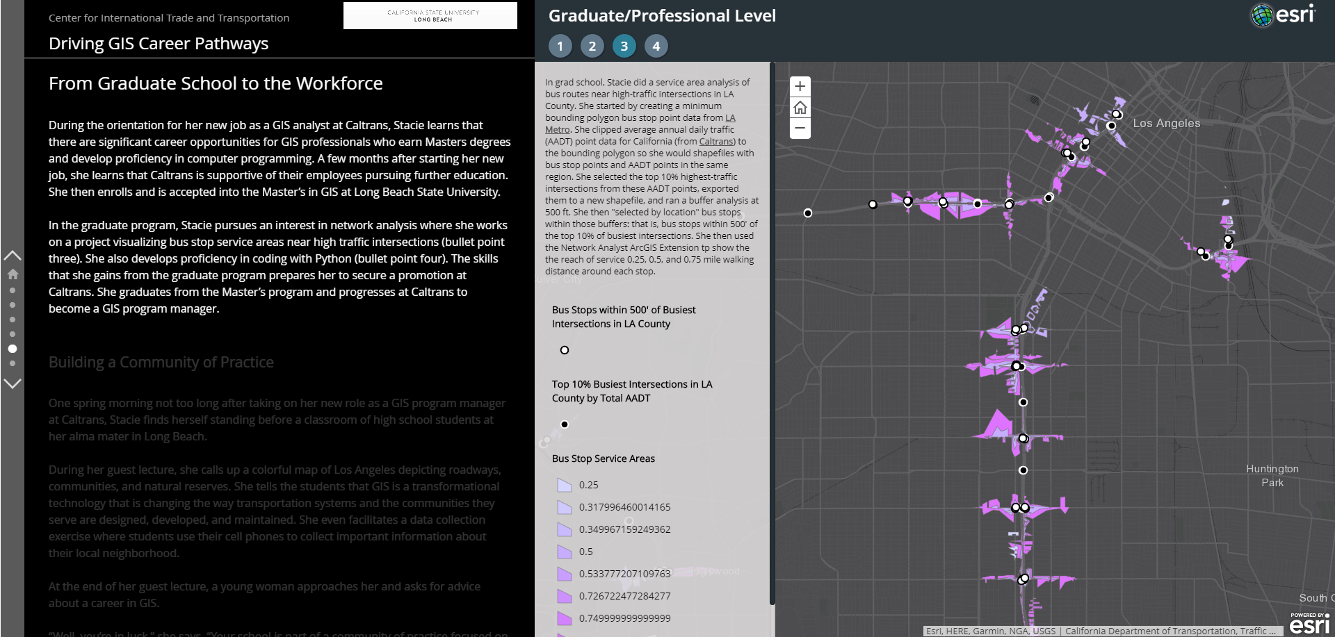
Their Story Map, entitled “Driving Geographic Information Systems (GIS) Career Pathways,” outlined the journey of a fictional student progressing through a GIS-driven career pathway. Beginning with a fateful day in her World Geography class at school, “Stacie” is introduced to GIS through guest lecturers from Caltrans. She is then inspired to sign up for a GIS co-enrollment course held at Los Angeles Trade Technical College (LATTC), which then prompts her to earn a GIS certificate, a BA in Geography, and a Masters in GIS at Long Beach State.
Olson and Reseigh created a geo-spatial map to illustrate each phase of Stacie’s narrative. For example, they included a service area analysis of bus routes near high-traffic intersections in LA County, which was a project that Stacie completed in graduate school. They also included a Career Pathway table along the way, demonstrating the potential jobs and salaries available to Stacie based on her completed level of education and experience in the GIS field.
This Story Map exemplifies the powerful synthesis that SCAG’s competition and conference offered. Drawing from real programs in practice, such as the LATTC dual-enrollment GIS class, ArcGIS technology, SCAG regional data, and accessible narrative techniques, “Driving GIS Career Pathways” serves as an ideal artifact of CITT’s Career Pathways Initiatives.
To view the “Driving GIS Career Pathways” Story Map, visit: https://arcg.is/0P1qia
To read more about the Esri Story Map Contest, visit their website: http://bit.ly/2kfbYX7
News Archive
- December (1)
- November (6)
- October (4)
- September (2)
- August (3)
- July (4)
- June (3)
- May (7)
- April (8)
- March (11)
- February (8)
- January (7)
- December (7)
- November (8)
- October (11)
- September (11)
- August (4)
- July (10)
- June (9)
- May (2)
- April (12)
- March (8)
- February (7)
- January (11)
- December (11)
- November (5)
- October (16)
- September (7)
- August (5)
- July (13)
- June (5)
- May (5)
- April (7)
- March (5)
- February (3)
- January (4)
- December (4)
- November (5)
- October (5)
- September (4)
- August (4)
- July (6)
- June (8)
- May (4)
- April (6)
- March (6)
- February (7)
- January (7)
- December (8)
- November (8)
- October (8)
- September (15)
- August (5)
- July (6)
- June (7)
- May (5)
- April (8)
- March (7)
- February (10)
- January (12)
2024
2023
2022
2021
2020
2019
2018
2017
2016
2015
2014
2013
2012
2011
2010
Major Funders


Metrans Associate Partners